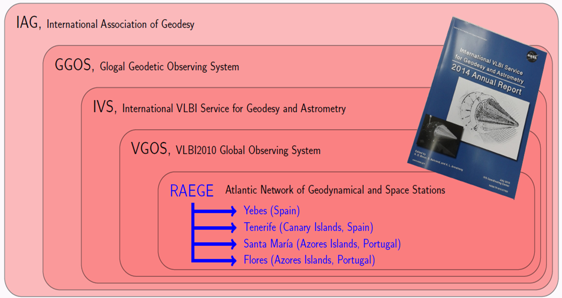
IAG
The International Association of Geodesy (IAG) is an international scientific organization in the field of geodesy. It promotes scientific cooperation and research in geodesy on a global scale and contributes to it through its various research bodies. The mission of the association is the advancement of geodesy. The IAG implements its mission by furthering geodetic theory through research and teaching, by collecting, analyzing, modeling and interpreting observational data, by stimulating technological development and by providing a consistent representation of the figure, rotation, and gravity field of the Earth and planets, and their temporal variations.
GGOS
GGOS is the Observing System of the IAG. GGOS works with the IAG components to provide the geodetic infrastructure necessary for monitoring the Earth system and for global change research. One of the requirements for the GGOS core site is co-located multi space geodetic techniques; VLBI, SLR, GNSS, and DORIS. One thing to be considered for VLBI in such a GGOS core site is radio frequency interference (RFI) from other techniques. It provides observations of the three fundamental geodetic observables and their variations, that is, the Earth’s shape, the Earth’s gravity field and the Earth’s rotational motion. It integrates different geodetic techniques, different models, different approaches in order to ensure a long-term, precise monitoring of the geodetic observables.
IVS
Prior to the existence of the IVS, most of the scientific and operational activities in geodetic and astrometric VLBI were organized through national or bi-lateral agreements, sometimes on an ad hoc basis. It was established in 1999 to operate or support VLBI components. Today the global VLBI resources and observing plans are coordinated by the IVS. The IVS, in turn, is an integral part of the GGOS. Its aims to provide a service to support geodetic, geophysical and astrometric research and operational activities. Also to interact with the community of users of VLBI products and to integrate VLBI into a global Earth observing system. GGOS is consider the overall “umbrella” system which coordinates and integrates the geodetic activities on a global scale. Detailed information in [1].
VGOS
It aims to improve VLBI data to meet increasingly demanding requirements. The key concepts are a broadband signal acquisition chain (2-14 GHz) with digital electronics and fast, small antennas. Radio Frequency Interference (RFI) should be recovered and the requisite observation precision achieved. Fast antennas will provide many more observations. VGOS is being developed to be minimally staffed, remotely controllable, broadband, RFI avoiding, fully digital, fast slewing, and capable of producing VLBI delays with precision of 4 picoseconds (in 4 picoseconds light travels 1 millimeter). The system is designed to observe continuously.
RAEGE
It consists of a network of four Geodetic Fundamental Stations in Spain (Yebes and Tenerife), and Portugal (Azores Islands of Santa María and Flores), as part of the developments needed to set up a VGOS. Each Geodetic Fundamental Station in RAEGE will be equipped with one radio telescope of VLBI2010 specifications (13.2-m diameter, able to operate up to 90 GHz, fast slewing speed), one gravimeter, one permanent GNSS station and, at least at the Yebes site, one SLR facility.
The current project aims at developing new instruments and devices for radiotelescopes for earth and space stations all over the world to make highly accurate geodesic measurements (in the order of one millimeter for intercontinental measurements) and very high sensitivity astronomic observations. The project could be framed in the field of the Global Geodesic Observation System (GGOS) in the International Association of Geodesic (IAG). The final goal of these associations is to improve in an order of magnitude the accuracy and stability of the measurements in the International Terrestrial Reference Framework (ITRF) aiming at improving the research on the Earth Sciences. Different countries are currently starting different developments around the previous strategies by launching new geodesic stations that integrate new spatial geodesic techniques. Spain is involved in these projects through the work in the Instituto Geográfico Nacional (IGN) which is nowadays taking part in the RAEGE (Red Atlántica de Estaciones Geodinámicas y Espaciales) project. This framework proposes the construction of four stations in Spain and 20 all over the world. The results of the project would be tested in the Yebes Observatory and would help to show the project in the RAEGE framework.
Previously to that goal, high technological developments in electronic instrumentation are needed. This proposal faces at these developments based on both high frequency electronic and/or optoelectronic approaches. The experience of the participating groups assures achieving these goals. The designed prototypes will be tested at the Observatorio de Yebes and will be shown in the framework of GGOS. Particularly, in order to provide radiotelescopes with the required and improved techniques needed for VLBI (Very Long Baseline Interferometry) for geodesic studies, it is essential the design of new and high performance electronics in radiofrequency for antennas, receivers and accessory instrumentation. The design of these microwave components is a challenge for the international community in geodesic stations for the new standard VLBI2010. The design and construction of a feeder prototype and auxiliary instrumentation will be a reference for new VLBI stations.
In addition to the improvements in the microwave receiver, the proposal also aims at introducing accessory instrumentation that allows getting better sensitivities, accuracy and calibration in astronomic and geodesic observations thanks to the use of optoelectronic techniques.
The required accuracies in determining the Earth position are not possible unless complementary techniques are introduced. Then the coordinated observation with techniques such as GNSS will make possible systematic errors. Then, optic accelerometers (based on electronic sensors and on photonic integrated circuits) will be studied to detect the movement of structures improving the performance of current accelerometers. These new optic accelerometers will be able to generate and distribute very high quality signals. All these developments will finish with measurement campaigns in the high accuracy geodesic VLBI that will result in obtaining millimeter accurate base lines. This fact will open new research lines in fundamental areas in the Science of Earth fields.
Finally this project matches the goals of the Comunidad de Madrid call specifically aiming at the line of “Advanced Techniques and Instrumentation for spatial Observation” in the AREA 3. It is expected that its results significantly improve the accuracy of the geodesic measurements in one order of magnitude thanks to the technological innovation in the radiotelescope receivers and to the scientific innovation in the error models. In short, this implies the improving in the equipment and instruments in the radiotelescope. In medium and long intervals this project will aim at integrating in international geodesic projects in Earth Sciences looking for high impact solutions for problems such as the climatic change, prevention of natural disasters such as earthquakes, etc. It is a multidisciplinar project interweaving different techniques and research lines such as microwave engineering, astronomy, geodesic and geophysics.